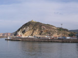
Ghazaouet is aa medium-size commercial port protected by a breakwater.It is capable of handling general cargo, passengers, bulk minerals and grain, edible oils, and ro-ro traffic. There is no tidal rise. The water level increases with W winds and decreases with E winds.
- Your comments are welcome - If you would like to add your own report on a marina, harbour, beach or anchorage please click on the "Edit" tab above, delete this text and type your comments. Digital photos are also very welcome using the "photo" link in the left menu. - Regards - The Webmaster
- Your comments are welcome - If you would like to add your own report on a marina, harbour, beach or anchorage please click on the "Edit" tab above, delete this text and type your comments. Digital photos are also very welcome using the "photo" link in the left menu. - Regards - The Webmaster


 Small port protected by a breakwater.
 Petit port protégé par une digue.