

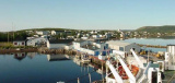

Digby
2.3nm
279°
23 Apr 11
Anonymous
| Latitude | Longitude | |
| DMS | --- | --- |
| DM | --- | --- |
| DD | --- | --- |

 The Bay of Fundy (French: Baie de Fundy) is a bay located on the Atlantic coast of North America, on the northeast end of the Gulf of Maine between the Canadian provinces of New Brunswick and Nova Scotia, with a small portion touching the U.S. state of Maine. The Bay of Fundy is known for having the greatest difference in water level between its high and low tides in the world. The name "Fundy" is thought to date back to the 16th century when the Portuguese referred to the bay as "Rio Fundo" or "deep river".
Ebook | Canada East
|
 La baie de Fundy est un bras de mer situé sur la côte Atlantique du Canada, à l'extrémité nord du Golfe du Maine, entre les provinces du Nouveau-Brunswick et de Nouvelle-Écosse. Le nom « Fundy » daterait du XVIe siècle, lorsque les Portugais la dénommaient baie « Rio Fondo » ou « rivière profonde ». Ce pourrait aussi venir, plus vraisemblablement, d'une mauvaise traduction (Fundy Bay) de l'expression française « fond de la Baie... », car cette baie fut également appelée Baie française par l'explorateur et cartographe Samuel Champlain durant l'expédition de 1604, conduite par Pierre Dugua de Mons, et à la fin du XVIIe siècle la colonie française s'étendait au « fond de la Baie française », jusqu'à « la Grand'Prée » (sic), devenu le Grand-Pré rasé par les Anglais en 1755, près de l'actuel Truro (Nouvelle-Écosse).