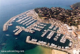
Baie de Cavalaire is surrounded by hills which slope gradually to its shores. It is entered between Cap de Cavalaire and Cap Lardier, 3.7 miles E. Numerous villas are scattered along the head of the bay, and a conspicuous hotel stands close to the shore, 1 mile N of Pointe de Cavalaire.
Baie de Cavalaire offers shelter from the Mistral, but is untenable during winds from the E through S to SW. The bottom, consisting of mud and weed, is a good holding ground provided vessels do not anchor in too great depth where the steep slope may cause dragging.
2011/07/16
Update
Agien
Free anchoring is prohibited in the bay.
There are moorings available at a reasonable price. Beware of wind and waves that come from different directions. This can make this place uncomfortable during the night.
2012/07/26
Update
Joëlle
Entre le Cap de Cavalaire et le Cap Lardier, la large baie de Cavalaire ne lève jamais une houle très grosse, elle est bordée d'une longue plage de sable coupér par les petites avancées des pointes de Cuisses et Vergeron. Le rivage ne devient rocheux et escarpé que 2 milles avant le cap Lardier après la pointe du Breuil où l'on trouve un mouillage abrité par vent d'E sur son flanc N.
2010/09/19
Update
Mouillage sur fond de sable après le troisième épis de rochers de bonne tenue dans 5 mètres d'eau. La houle qui rentre dans la baie peut rendre le mouillage inconfortable si elle est significative. Il existe des bouées de mouillage organisé devant l'entrée du port en saison et demie saison ( dates à vérifier ). En demie saison il vous sera demandé de passer par la capitainerie du port pour payer votre nuitée...C'est très pratique, surtout quand on a rien à faire à terre. D'après le "collecteur" il faut se plaindre à la mairie.
2015/06/23
Update
Roland Matras
La zone de mouillage sur corps-morts devant le port de Cavalaire. Il faut s'annoncer canal 9 (VHF) auprès de la capitainerie et une personne vient vous aider à vous amarrer à la bouée.
Olivier
16/07/2021
2021-07-16
Update
Olivier
Share your comments or photos on "Baie de Cavalaire"
Prohibited areas, the limits of which are shown on the chart, lie SW of Pointe du Titan (Ile du Levant) and extend up to 2 miles from the coast. These areas, which are used by French naval vessels, are not in force between July 1 and August 31. Vessels are prohibited from approaching ...
Ile de Porquerolles lies centered 3 miles SE of Ponte de l’Esterel. The summit of the island, located 1 mile from its E end, is 142m high and surmounted by a signal station.
Toulon is a large military harbour on the Mediterranean coast, with a major French naval base.The prevailing winds are from the NW (Mistral) and W. These winds may reach a velocity of Force 11. Winds from the E and SE, which are less frequent, are generally accompanied by rain squalls, ...
The port of Cavalaire is divised in 2 basins: the private port (port side) and the public port (starboard side). Approach: By 50m wide passage protected by the harbour wall jetty. The Mistral makes access difficult. Private port 542 B. Public port 580 B. incl. 40 visit. ...
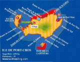
Ile de Port Cros, lies close E of Ile de Bagaud, is mainly wooded and is the highest island of the chain. Its summit, 207m high, is surmounted by a building, with two white cupolas, which are visible from a considerable distance. An islet, 63m high, lie 0.2 mile S of the S extremity ...
Golfe de Giens is entered between Pointe de Carqueiranne and Pointe Escampobariou, 4.7 miles SE. Pointe Escampobariou is the SW extremity of Presqu’ile de Giens, a peninsula, the W side of which is 118m high and surmounted by a tower. The E side of this gulf is bordered by ...


 La baie de Cavalaire
 La plage de Cavalaire
 Baie de Cavalaire is surrounded by hills which slope gradually to its shores. It is entered between Cap de Cavalaire and Cap Lardier, 3.7 miles E. Numerous villas are scattered along the head of the bay, and a conspicuous hotel stands close to the shore, 1 mile N of Pointe de Cavalaire.
 Entre le Cap de Cavalaire et le Cap Lardier, la large baie de Cavalaire ne lève jamais une houle très grosse, elle est bordée d'une longue plage de sable coupér par les petites avancées des pointes de Cuisses et Vergeron.
 La zone de mouillage sur corps-morts devant le port de Cavalaire. Il faut s'annoncer canal 9 (VHF) auprès de la capitainerie et une personne vient vous aider à vous amarrer à la bouée.