Il est interdit de naviguer à plus de 20noeuds dans l'intérieur de la zone délimitée vers le large par une ligne joignant l'îlot du cap Taillat aux rochers des Portes en avant du cap Camarat.
2010/05/25
Update
so long
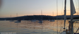
baie de bon porteau. Mouillage sur fond de sable à 3 mètres de fond. Idyllique !
Prohibited areas, the limits of which are shown on the chart, lie SW of Pointe du Titan (Ile du Levant) and extend up to 2 miles from the coast. These areas, which are used by French naval vessels, are not in force between July 1 and August 31. Vessels are prohibited from approaching ...
Ile de Porquerolles lies centered 3 miles SE of Ponte de l’Esterel. The summit of the island, located 1 mile from its E end, is 142m high and surmounted by a signal station.
Toulon is a large military harbour on the Mediterranean coast, with a major French naval base.The prevailing winds are from the NW (Mistral) and W. These winds may reach a velocity of Force 11. Winds from the E and SE, which are less frequent, are generally accompanied by rain squalls, ...
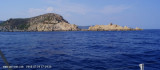
Cap Taillat, fronted by rocks, is the SE extremity of a peninsula which is 65m high and joined to the mainland by a low isthmus. A beacon stands on this cape.
Baie de Briande is entered between Cap Lardier and Cap Taillat, 1.2 miles NE. It offers shelter from the Mistral, but is exposed to all winds from seaward.
Cap Lardier may be identified by the grey color of its barren rocks. A wall, 4m high, stands on the cape and is prominent. A rock, with a depth of 7.1m, lies about 0.5 mile ESE of the cape.


 20 knots max.
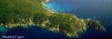
 Baie de Bon-Porte à l'Est de Cap Taillat.