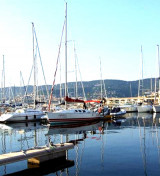
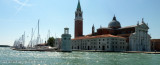
Le bassin Sacchetta se trouve au SW du Port Franco Vecchio; à l'intérieur il y a quelques pontons gérés par deux société privées: l'Assonautica et la Société Triestina della Vela.
Accès: attention aux navires marchands en transit.
Profondeurs: de 2 à 14 m Tel: 040-676611 Mail: trieste@guardiacostiera.it 400 pl
2011/03/20
Update
Joëlle
Il Bacino Sacchetta si trova a SW del Porto Franco Vecchio; nel suo interno vi sono alcuni pontili in gestione a due società private: l'Assonautica e la Società Triestina della Vela.
Accesso: prestare attenzione alle navi mercantili in transito.
Fondali: da 2 a 14 m. Tel: 040-676611 Mail: trieste@guardiacostiera.it 400 pb
Koperski Zaliv (Baia di Capodistria) is entered between Rt Ronco and Rt Debeli, 5 miles NE.The NE and SW shores of the bay are hilly, but the shore at the head of the bay, through which the Fiume Risano flows, is low. Monte Sermino, surrounded by salt beds, rises isolated in the river ...
The Gulf of Piran or Piran Bay (Slovene: Piranski zaliv, Croatian: Piranski zaljev or Savudrijska vala, Italian: Baia di Pirano) is located in the northern part of the Adriatic Sea, and is a part of the Gulf of Trieste. It is between Rt Madona at N and Rt Saudrija. It was named ...
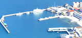
La marina s'étend sur 3 lignes de pontons adossés au quai du môle Venezia et Pêche et du quai "T".Dangers: pendant la période estivale attention aux ferries grecs qui manœuvrent pour l'entrée et la sortie du port, à côté du quai Bersaglieri (mardo, mercredi, vendredi, samedi ...
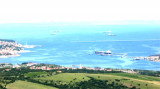
Le port de Trieste est le plus important de l'Adriatique et est subdivisé en trois secteurs principaux:Port Franco Vecchio, Port Draganale (composé du bassin Sacchetta et du port du Lido et la marina San Giusto) Port Franco Nuovo.Port Franco Vecchio est formé de 5 quais et de ...


 canal 16, 11


 Le bassin Sacchetta se trouve au SW du Port Franco Vecchio; à l'intérieur il y a quelques pontons gérés par deux société privées: l'Assonautica et la Société Triestina della Vela.
 Il Bacino Sacchetta si trova a SW del Porto Franco Vecchio; nel suo interno vi sono alcuni pontili in gestione a due società private: l'Assonautica e la Società Triestina della Vela.