Prohibited areas, the limits of which are shown on the chart, lie SW of Pointe du Titan (Ile du Levant) and extend up to 2 miles from the coast. These areas, which are used by French naval vessels, are not in force between July 1 and August 31. Vessels are prohibited from approaching ...
Ile de Porquerolles lies centered 3 miles SE of Ponte de l’Esterel. The summit of the island, located 1 mile from its E end, is 142m high and surmounted by a signal station.
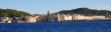
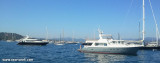
Situated on the lovely blue waters of the Bay of St. Tropez, the quay is lined with terrace cafes, perfect places to linger as the clientele admire the yachts docked there. Situated on the S side of the gulf of St-Tropez the harbour is made up of 2 basins (10 hectars) which get ...
Cap de Saint-Tropez, the E extremity of a peninsula, is bordered E and NE by foul ground. Basse du Verhuge lies about 2 miles ESE of the cape and has a depth of 13.7m. This shoal is dangerous in bad weather when the sea breaks violently over it. Teste-de-Can, a group of three ...


 Nice anchoring place protected from E/S/W winds.
 Baie ou Anse des Canebiers. Belle baie qui offre un bon mouillage protégé de l'E/S/W. Fonds d'herbes et sables.