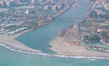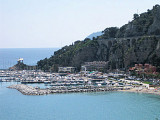
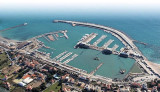

Marina di Loano
2.3nm
347°
più affascinanti, vicini ad ambite mete del turismo nautico internazionale.
Serviti da autostrade e ferrovie, a un'ora dagli aeroporti di Genova ...
3 Jan 11
Joëlle
| Latitude | Longitude | |
| DMS | --- | --- |
| DM | --- | --- |
| DD | --- | --- |


Ebook | Ligure Ligurian Sea
|
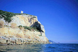
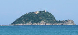
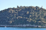
 La Riviera ligure di ponente è la regione geografica che comprende il tratto di costa della Liguria noto nella sua totalità come riviera ligure. Si estende ad occidente di Genova fino al confine francese, in prossimità della città di Ventimiglia.
Le correnti lungo la costa, e la testa in genere E W, si sentono a 1 o 2 NM offshore in prossimità di rafforzare tappi.
La loro velocità media è di 1 nodo, ma a volte può raggiungere i 2 nodi. Contro le correnti a basso può essere sentito vicino alla costa.
 La Rivera Ligure se trouve à l'Ouest de Gênes et s'étend jusqu'à la frontière française. La frontière aboutit à l'embouchure de la rivière Saint Louis (S. Luigi).
Les courants qui suivent la côte, et se dirigent généralement d'E en W, se font sentir à 1 ou 2 MN au large en se renforçant au voisinage des caps.
Leur vitesse moyenne est de 1 n?ud, mais peut atteindre 2 n?uds quelquefois. De faibles contre courants peuvent se faire sentir près de la côte.
 In the Ligurian Sea or Golfe di Genova, the prevailing wind is from the NW practically all year. However, locally along the coast, there is some variation due to the land configuration. In the N part of the Tyrrhenian Sea, the most prevalent winds are from the SE, W, and NW.
Fog is not common and the little that does set in usually occurs during the early morning and lifts shortly after sunrise.
Tides, tidal currents, and surface currents within this area are generally negligible. The greatest fluctuation of water level is caused by wind action and atmospheric pressure gradients.