The Republic of Peru is a country in western South America. It is bordered on the north by Ecuador and Colombia, on the east by Brazil, on the southeast by Bolivia, on the south by Chile, and on the west by the Pacific Ocean. Sailing Keep a close eye for small fishing boats off the coast of Peru, some were not lit and hard to see on RADAR.
Arrival
Yachts are required to advise either of the stations at Paita, Callao or Mollendo well in advance of arrival. Call the Marine Authority (TRAMAR) on VHF or HF. After having entered territorial waters (200 miles), you are expected to proceed directly to an official "port of entry".
La isla Sala y Gómez1 o Salas y Gómez2 3 4 (Motu Motiro Hiva en rapanui, «islote del ave en el camino a Hiva») es una isla deshabitada situada en el océano Pacífico suroriental, perteneciente a Chile. Es el límite oriental de la Polinesia y en consecuencia, también de Oceanía.
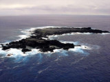
As you approach Isla Isabela from the east, there is a small island to
the south of Villamil in the shape of a half moon, called Isla Tortuga
and a small rock to the north of it, called Roca Bura. If you approach
the island in the dark, shape a course to go between the two and ...
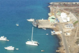
Anchor in front of Hotel Wittmer, to the right of the Port Captain
building off brown sand beach. Lots of rocky areas, but good holding in
course sand off this beach. SHE WOLF first tried to anchor closer to
Port Captain, but just volcanic rock bottom there. Dinghy Landing: ...
On the southwestern shore of Baltra island is a pontoon allowing small ferries to the transfer of passengers and light vehicles Itabaca by the channel to the island Santa Cruz and rally the main city of the archipelago, Puerto Ayora. Easy entrance. The charts call it Caleta Aiolian, ...
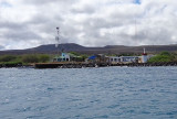
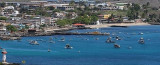
Puerto Baquerizo Moreno is the capital of the province of Galapagos. It is the main port, located on the southwertern tip of San Cristobal island. Entry Information: On approach, stay clear of the SE point. Come in
midway between the North point of land, which has a lighthouse ...