Nightingale Island is an island in the South Atlantic Ocean, 3 km² in area, part of the Tristan da Cunha group of islands. They are administered by the United Kingdom as part of the overseas territory of Saint Helena.
2009/09/4
Aggiornare
Mega06
Condividi i tuoi commenti o le foto su "Nightingale Island"
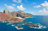
Inaccessible Island is an extinct volcano, 14 km². It is a territory of the United Kingdom, although throughout its history it has had no permanent population. Together with Gough Island, it is a protected wildlife reserve which has been designated a World Heritage Site by UNESCO.
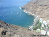
All visiting vessels should seek advice from the Harbourmaster on a safe anchorage position (GPS: Lat 37 03.10S/Long 12 18.60W or Lat 37 03.04S/Long 12 17.85W) in the open anchorage below the Settlement (max depth 100m ? 50m due to shelving bottom).No visas are required. All visitors ...
L'île Gough aussi connue sous le nom de Diego Alvarez - est une des îles de l'archipel britannique Tristan da Cunha, située dans le sud de l'Atlantique Sud.
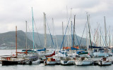
Mouillage dans + ou - 12-15 m., sauf un seul petit espace où il est possible de mouiller dans 8m. plus près de la rive.Ile magnifique, habitant courtois, service de bateaux taxi et plusieurs belles randonnées pédestre qu'il ne faut pas manquer.


 Nightingale Island is an island in the South Atlantic Ocean, 3 km² in area, part of the Tristan da Cunha group of islands. They are administered by the United Kingdom as part of the overseas territory of Saint Helena.