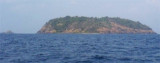
Kerekund island (W India)
4nm
177°
Between Kerekund and Bhatkal Fort, about 4.5 miles SE, the low and sandy ...
8 Mar 12
Jojo
| Latitude | Longitude | |
| DMS | --- | --- |
| DM | --- | --- |
| DD | --- | --- |

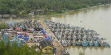
 The coast between Honavar and the entrance to the Bhatkal River, is low and sandy with some rocky points. A ridge, reaching an elevation of about 150m, extends about 2 miles along the coast from a position about 3 miles S of Honavar.
Murdeshvar, an islet 32m high, lies about 6.5 miles S of the above ridge.
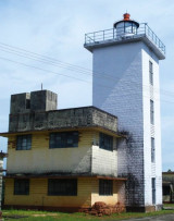
A rocky island, 9m high, lies about 0.8 mile SW of Murdeshvar at the W end of foul ground extending from the coast.
Hawkins Reef, awash, lies with its SW extremity about 1 mile NW of Murdeshvar and about 1 mile offshore.
Dart Rock, with a least depth of 2m, lies about 1.8 miles WSW of Murdeshvar.
Ebook | Arabian Sea
|