Chowra Island, which lies about 24 miles SSE of Batti Malv Island, is generally low but rises to a 104.5m high rocky pinnacle at its S end. The island looks like a hat from the offing. Sanenya, the principal village, lies on the NE coast. It has area of 8.2 sq km with a population ...
Nancowry Island lies close S of and overlaps the S end of Camorta Island. Nancowry Harbor, a secure landlocked inlet, lies between them. The E entrance of Nancowry Harbor lies between the SE end of Camorta Island and the NE end of Nancowry Island. The approach to this entrance leads ...
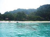
Bompoka island lies about 1,8 NM east from southern end of nearby Teressa Island in the Nicobar group of islands. The hills on the island rise upto 193 m. The island
has dense forest and some portions have grass growth. There is thick
coconut palm growth on shores all round ...
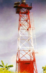
Bompoka lighthouse is on SW point of the island. Only the locals can approach the landing point
safely as there are submerged rocks around. From the landing point the
Lighthouse is about 4 km through forest and hilly track. It is
advisable to visit Bompoka island by engaging ...
Trinkat Island, which lies between 1.5 and 2.5 miles E of the S part of Camorta Island, is separated from that island to the W and NW by False Bay and Beresford Channel. Trinkat Island is low, level, and covered by coconut trees. An extensive reef surrounds the island. Morrel Point, ...


 Anchorage can be taken by small vessels with local knowledge close off Hinam Village, in depths of 11 to 25.6m.