
Khwr Umm Al Qaywayn port
14nm
237°
10 Oct 11
JB Antibes
| Latitude | Longitude | |
| DMS | --- | --- |
| DM | --- | --- |
| DD | --- | --- |
 channel 6, 16
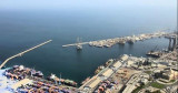
 Al Jazira port fronts Jazirat al Hamra, which was once an island but is now part of the mainland.
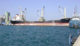
The port exports rock and aggregates from nearby quarries but can also handle bulk, liquid, ro-ro, container, and general cargo.
Tides—Currents.—The mean maximum tidal range is 0.5m. The mean minimum tidal range is 0.4m.
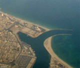
Depths—Limitations.—The port is approached from the NW through a 1-mile wide channel, marked by lighted buoys, with general charted depths of 5.5 to 20m, although caution must be used to avoid the charted 2.3m and 4.2m patches along the SW side of the approach channel.
The dredged inner channel, which has a contolling depth of 6m and is marked by lighted buoys, is entered about 0.3 mile NNE of Ras Abu Ahmad Light; however, the positions of the lighted buoys do not indicate the actual limits of the dredged channel.
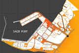
The port has six numbered berths. Berth 4 through Berth 6 are 400m long, with an alongside depth of 6m. Berth 2 and Berth 3 are located on the SSW-facing jetty; Berth 1, which is under construction, is located close SSE.
Aspect.—The harbor consists of two basins enclosed to the W by Ras Abu Ahmad. A rock breakwater extands about 0.2 mile NNW from the point.
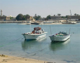
A light is shown from Ras Abu Ahmad on the NW side of the entrance channel. There is a fort with several towers in the town; close to the fort is a high square tower. Another slender tower rises at the W end of town. Landing on the shores outside the inlet is difficult, except during good weather.
Regulations.—Vessels must send the ETA to the pilot office at least 24 hours in advance, except when vessels are on a passage from a port less than 24 hours sailing time, in which case the ETA should be sent no later than upon departure from the previous port.
Any amendments to the ETA should be sent as soon as possible, but not later than 2 hours prior to arrival.
Harbor Control should be advised of the following information 30 minutes prior to arrival off the breakwater light:
1. Vessel name.
2. Vessel flag.
3. Length overall.
4. Gross tonnage.
5. Net registered tons.
6. Arrival draft.
7. Last port of call.
8. Next port of call.
9. Type and tonnage of cargo for discharge and loading.
Contact Information.—The port can be contacted, as follows:
Tel: 971-7-2446627
Fax: 971-7-2446651
Mail: alhmra@emirates.net.ae
Aspect.—A square fort near the center of the town has two round towers and a flagstaff. A conspicuous minaret stands close SW of the fort. Bakhut Tower, conspicuous from N and WNW, stands on the E side of the peninsula. West of the peninsula are three other towers, of which Mashsum Tower is conspicuous.
A conspicuous square water tank stands on a hill 2 miles SSW of Umm al Qaywayn.
Anchorage.—Anchorage outside the inlet may be obtained, 17.8 to 21.0m, is located about 5.5 miles NW of Ras Abu Ahmad.
Anchorage is prohibited in an area centered on position 25°44.8'N, 55°47.0'E.
Directions.—Vessels approaching from the NE should pass 10 miles E of Saleh Oil Field.
Caution.—The position, shape, and depths over the offshore banks within the 10m curve can be affected by the shamal.
")
Ebook | Persian Gulf - Arabian Gulf
|