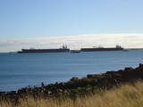

Darwin
175nm
94°
5 Sep 12
samuelmcadams
| Latitude | Longitude | |
| DMS | --- | --- |
| DM | --- | --- |
| DD | --- | --- |

 The Timor Sea (Indonesian: Laut Timor; Portuguese: Mar Timor) is an arm of the Indian Ocean situated between the island of Timor, now split between the states of Indonesia and East Timor, and the Northern Territory of Australia. The waters to the east are known as the Arafura Sea, technically an arm of the Pacific Ocean. The Timor Sea has two substantial inlets on the north Australian coast, the Joseph Bonaparte Gulf and the Van Diemen Gulf. The Australian city of Darwin is the only large city to adjoin the sea.
Ebook | West Australia
|