Teluk Karang Raba (Kruengraba Kroeeng Raba) (E Sumatra)
Latitude
Longitude
DMS
---
---
DM
---
---
DD
---
---
Caractéristiques
Description
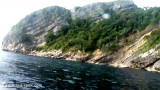
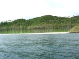
Teluk Karang Raba, lying 2,5 miles S of Ujung Raya, is about 4 miles wide. The mountains on either side make it appear as a valley when being a considerable distance off, and it has been mistaken for Aroih Cut.
There is a cement-handling pier in the bay. The pier is 125m long with a depth of 10m alongside. Vessels with a maximum length of 150m and a maximum draft of 9.1m can be accommodated. Pilotage is compulsory. The pilot boards 1.75 miles WNW of the breakwater light. Vessels can obtain anchorage, in 22m, about 2 miles NW of the light.
Pulau Nasi (Peunasoe or Aceh island), nearly joins the SE point of Pulau Breueh, being separated by Aroih Lam Puyang. The coast line is rocky in places with sandy beaches chiefly on the W side.
Lhok Prialaut is the bay lying between Ug Bau and Ug Seukundo. 6,5 NM appart, between wich points the bay extends S for about 4 NM, with Teluk Sabang on its E shore. Lhok Prialaut is about 2 miles in length and breadth, with good anchorage near its head, in 16.5 to 21.9m. Tides—Currents.—The ...
Pulau Bunta (Pulau Boenta) lies between Aroih Raya and Aroih Cut (Aroih Tjoet).
Pulo Bunta is the least interesting of the bigger islands in Pulo Aceh. It
has a light house and a few beaches, but difficult to swim due to the
barrier reefs and strong currents. There are no people ...
Pulau Batee, lying about 1 mile NE of the E end of Pulau Bunta, is mostly wooded, and rises to 129m. The island is long and narrow. The mountain range runs along its NE side. Pulau Batee is borded at its E side by Pulau Lumpai and at the W side, by Pulau Usamlakoh . The spectacular ...


 Teluk Karang Raba, lying 2,5 miles S of Ujung Raya, is about 4 miles wide. The mountains on either side make it appear as a valley when being a considerable distance off, and it has been mistaken for Aroih Cut.