Teluk Balohan, on the SE side of Pulau We, is nearly 2 miles in length, and 1.5 miles in breadth across the entrance, with depths of from 54.9 to 128m in the outer part.
A reef fringesthe E and W shores of the bay for a distance of 91m. A narrow coral bank fringes the shores of the bay.
Anchorage may be obtained, in not less than 29.3m, about 91m off the sandy shore at the head of the bay. It can be used in both monsoons, but most shelter is afforded during the Southwest Monsoon.
A Ferry harbor is at the bottom of this natural bay where is a fisherman's village.
Pulau Nasi (Peunasoe or Aceh island), nearly joins the SE point of Pulau Breueh, being separated by Aroih Lam Puyang. The coast line is rocky in places with sandy beaches chiefly on the W side.
Lhok Prialaut is the bay lying between Ug Bau and Ug Seukundo. 6,5 NM appart, between wich points the bay extends S for about 4 NM, with Teluk Sabang on its E shore. Lhok Prialaut is about 2 miles in length and breadth, with good anchorage near its head, in 16.5 to 21.9m. Tides—Currents.—The ...
Karang Berduri, a rock small and awash, lies about 0.3 mile S of the S extremity of the island. A rock with a depth of 5.5m lies about 0.2 mile SE of the same point. There are usually strong tide rips or overfalls near these rocks and frequently they have been observed as breakers.
Island located in Sabang bay, with an average elevation of 56 m above the sea level and can only be travelled by boat or small boat. In this island there is a beacon to guide shipping traffic at night.
To the S of Pulau Klah near the head of Teluk Sabang, is Lho Krueng Raja, a small bay about 0.5 mile long and 0.25 mile wide. It is approached by a channel less than 183m in width to the E of Pulau Klah, with depths of about 5 to 6.9m, but inside it deepens to 18.3m over mud.
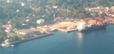
Teluk Sabang is nearly 1 mile in length, the entrance being about 0.4 mile wide and the depths from 20 to 40m, with a bottom of sand, coral, and gravel.
A light is shown from the N side of the entrance of Teluk Sabang. The E side of Teluk Sabang is fronted by a bank with depths ...


 Teluk Balohan, on the SE side of Pulau We, is nearly 2 miles in length, and 1.5 miles in breadth across the entrance, with depths of from 54.9 to 128m in the outer part.
")
")
")