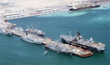
King Abdul-Aziz Naval Base (KANB) is located just south of the steadily growing Jubail commercial port and industrial complex.KANB has extensive waterfront operational and protective works, drydocking and shop repair facilities, a training complex for several hundred students ...
At Mina Salman, the Deep Water Jetty, which is 30m wide and 800m long, extends SE into Khawr al Qulayah and provides ten berths, each 150m in length. Berths 1, 3, 5, 7, and 9 are on the N side of the jetty, while Berths 2, 4, 6, 8, and 10 are on the S ...
Khawr al Qulayah is an extensive inlet circled by and containing reefs and other dangers best seen on the chart. A channel, with a least depth of 9.5m, leads through Khawr al Qulayah to a basin, with the same depth, off Mina Salman, although caution is necessary, ...


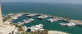


 Petit port protégé par une digue.
 Small port protected by a breakwater.