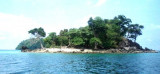
Pulau Peunasoe (Nasi) (SE Breueh)
27nm
174°
The coast line is rocky in places with sandy beaches chiefly on the W side.
11 Jan 12
Jojo
| Latitude | Longitude | |
| DMS | --- | --- |
| DM | --- | --- |
| DD | --- | --- |


 Pulau Rondo is the northwesternmost of the islands lying off Ujung Masam Muka, the NW point of Sumatera, about 15 NM NW of Beueh island.
The island is 153m high, wooded, steep-to on its N side, and about 30 miles offshore. It appears from all sides as a flattened half sphere. Rocky islets lie on a reef which extends about 1 mile S from the islands SW side and is steep-to on its outer edge. Ocean-going vessels bound E pass N of Pulau Rondo.
The island is inhabited and is sometimes visited by scuba divers. There is also a small Indonesian military outpost on the island. Accessible only boat.
An off-lying bank, with a least depth of 51m, coral rock and sand, lies with its center located about 13 miles NW of Pulau Rondo.
Anchorage may be obtained, in a depth of about 14m, during the Northeast Monsoon, with the SW extremity of Pulau Rondo bearing 103° and the NW extremity bearing 044°.
There are strong tide rips off the island and up to 20 miles WNW.
")
") Rondo spot
Rondo spot") Pulau Rondo lighthouse
Pulau Rondo lighthouseEbook | Andaman sea
|