Pulau Reusam (W Sumatra)

Pulau Reusam (W Sumatra)

Pour géolocaliser ce lieu. Mettre à jour si besoin.

Localisation

Pulau Reusam (W Sumatra)
LatitudeLongitude
DMS------
DM------
DD------

Caractéristiques

Île / Atoll
Mouillage
Sable
Plage
Sable
Plongée

Description

Pulau Reusam, the largest and highest of the four islands in Rigaih bay, is surrounded by a reef. Two shoals, with depths of 3.7 to 5.5m, lie about 0.1 mile W of Pulau Reusam.
A patch, with a depth of 5.9m, lies about 0.1 mile E of Pulau Reusam.

Vessels making any stay at Teluk Rigaih are recommended to moor W or S of Pulau Reusam, where there are depths of about 15m, sand and mud.

Between Teluk Rigaih and Meulaboh, about 47 miles SE, the coast is low with flat land stretching a great distance inland.
There are no off-lying dangers on this part of the coast.
The depths are regular, but it is recommended not to get inside the 20m curve at night, as within this depth soundings give little warning of being close inshore. This part of the coast is very uniform and without any remarkable features in the foreground.

2012/02/4
Mettre à jour
Jojo
Pulau Reusam (W Sumatra)
2012-02-04
Mettre à jour
Jojo
Ebook

Andaman sea

  • 178 sites
  • 164 photos
  • publication date: 7 Jul 2023
  • .pdf file size: 54 Mb
Partagez vos remarques ou photos sur "Pulau Reusam (W Sumatra)"

Sites autour de Pulau Reusam (W Sumatra)

Flying distances - Direct line

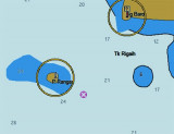
Teluk Rigaih (W Sumatra)

0.8nm
126°
Teluk Rigaih is nearly 2 miles wide and about the same in length; the coast is for the most part composed of rocky cliffs, excepting the swampy portion on its NE side. The four islands which encumber it divide the bay into the N and S harbors.
There is always a heavy swell in Teluk ...
4 Feb 12
Jojo

Ujung Baro (W Sumatra)

1.1nm
298°
Ujung Baro, the SW extremity of the peninsula within which is Teluk Rigaih, is a rocky headland rising steeply from the sea, covered with vegetation, and higher than the land within it. It is the N entrance point for Teluk Rigaih.
Gillis Reef, with a least depth of 3.4m, is about ...
3 Feb 12
Jojo

Pulau Rangas (W Sumatra)

2.1nm
254°
Pulau Rangas, lying about 2 miles SW of Ujung Baro, is a small rocky island 66m high, and covered with trees, which are visible for a considerable distance.
Two rocks above-water lie off its SE side, and a sunken rock, which always breaks, lies 91m off its NW side, all of which ...
3 Feb 12
Jojo

Pulau pulau Cikem (W Sumatra)

3.8nm
309°
Cikem islands are located about 1,2 NM S of Ug Glumpang. The W island is steep-to on its seaward side.The islands are densely wooded and joined by a reef.Pulua-pulau Cikem is in a seismicly active area with most recent activity being an earthquake in Simeulue on Wednesday 01st of ...
3 Feb 12
Jojo

Ujung Glumpang (Gloempang) (W Sumatra)

4.9nm
321°
Ujung Glumpang is a precipitous tongue of land crowned by a green hill with a few scattered trees on it.
A reef extends E from the point for about 0.1 mile and to a distance of 137m offshore. Foul ground extends about 0.3 mile S from Ujung Glumpang.
3 Feb 12
Jojo

Pulau Pulau Peyaba (Pejaba) (W Sumatra)

6.3nm
316°
Pejaba Islands, about 4 miles SSE of Pulau Keueh, consists of two wooded islands, with a low,rocky, barren islet, nearly always covered by surf, lying about 0.1 mile SW of the outer island.
A rock, nearly awash, lies 0.3 mile S of the inner island.
3 Feb 12
Jojo