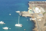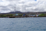

Puerto Velasco Ibarra (Floreana Island)
34nm
123°
Dinghy Landing: ...
18 Dec 15
Joëlle
| Latitude | Longitude | |
| DMS | --- | --- |
| DM | --- | --- |
| DD | --- | --- |


 As you approach Isla Isabela from the east, there is a small island to
the south of Villamil in the shape of a half moon, called Isla Tortuga
and a small rock to the north of it, called Roca Bura. If you approach
the island in the dark, shape a course to go between the two and avoid
going north of Roca Bura.
As you approach Isla Isabela from the east, there is a small island to
the south of Villamil in the shape of a half moon, called Isla Tortuga
and a small rock to the north of it, called Roca Bura. If you approach
the island in the dark, shape a course to go between the two and avoid
going north of Roca Bura.
There are breakers off Isla Isabela in this area and the swell picks up.
After passing Roca Bura and Tortuga, alter course to the WSW to pass
south of the shoals on the outside of Villamil and then to the NW to
parallel them and to intersect the inbound 029º track that is the
recommended course on the electronic chart (Chart 22529). (From the
ocean, two adjacent orange pyramids on shore - actually roofs of a
hostel - make a good day marker.) As you come in on the 029º course, it
leads off a white beacon on the beach. You will also see a green buoy
just to the left in the distance.
On the chart, you will also see a light on the north end of the reef
that you are leaving to starboard. The light on the chart has the
characteristics Fl(2+1)15s 11m 7M. This marks the entrance to the
anchorage area and is also marked by red/green channel markers, as well
as a new buoy that is large and yellow and marks the anchorage.
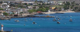
The anchorage area is bounded by low volcanic islets, is quite calm and
is a lot smaller than it looks as you enter, because it is mostly filled
with submerged reefs and shoals. Reefs are above water at low tide.
More protected, calm anchorage.
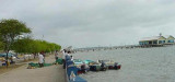
Dinghy Landing: You can land your dinghy across the anchorage to the left of the cargo pier (Embarcadero) in front of the little restaurant/bar called “Club Nautico”.
")