Nancowry Island lies close S of and overlaps the S end of Camorta Island. Nancowry Harbor, a secure landlocked inlet, lies between them. The E entrance of Nancowry Harbor lies between the SE end of Camorta Island and the NE end of Nancowry Island. The approach to this entrance leads ...
Trak Island lies 5 miles WNW of Sombrero Point; Treis Island lies 1 mile SE of Trak Island. Both islands are small, reef-fringed, and surrounded by sunken rocks. A rock, which has a depth of less than 1.8m, lies about midway between Treis Island and Sombrero Point.
Sombrero Channel separates the central and S groups of the Nicobar Islands. The channel is 30 miles wide between Cape Albany and Sombrero Point, the N extremity of Little Nicobar Island. The depths in the channel are irregular, but there is deep water in mid-channel.Strong tidal ...
Trinkat Island, which lies between 1.5 and 2.5 miles E of the S part of Camorta Island, is separated from that island to the W and NW by False Bay and Beresford Channel. Trinkat Island is low, level, and covered by coconut trees. An extensive reef surrounds the island. Morrel Point, ...
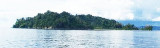
Kondul island, high and rocky on its N side, rises to a heigh of 92 m.
The shape of this island looks elongated. Kondul was amongst those
islands that were devastated by the tsunami of 2004. Population of
Kondul Island according to 2001 census is 150. Before tsunami hit this
island, ...
Kabra Island, 63m high, lies in St. Georges Channel almost 3 miles N of Murray Point, the N end of Great Nicobar Island.It is part of great Nicobar group of Islands. It has
thick growth of commercial vegetation. The inhabitants from nearby
Kondul and Little Nicobar islands ...


 Miroe Island, low and small, lies 10.5 miles WNW of Sombrero Point, the N extremity of Little Nicobar Island.