Las Brisas anchorage (Panama)

Las Brisas anchorage (Panama)

Pour géolocaliser ce lieu. Mettre à jour si besoin.

Localisation

Las Brisas anchorage (Panama)
LatitudeLongitude
DMS------
DM------
DD------

Caractéristiques

Mouillage
Sable

Description

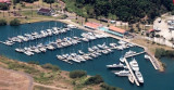
Las Brisas anchorage is located NW of isla Perica, on the causeway.

This anchorage tends to be used during the rainy season (April­December) due to prevailing S/SE winds. It can be quite rough during the dry season due to N/NE gap winds. During the rainy seaon expect frequent, sudden and violent storm squalls.

That said, holding in the main is excellent as long as you follow a few simple rules:
1) Back-up strongly on the anchorto test the hold;
2) Put out at least 150' of chain (not just rode) at thebottom; and
3) Give the boats around you ample swinging room.

There are a couple of places where the bottom is gravel/construction debris with bad holding, however the restof the anchorage is mostly mud and shell.

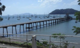
Access to the shore is via a non-maintained dinghy dock, currently free to yachtsmen. This landing is closer to the anchorage than the one at Flamenco Marina, however getting ashore can be a problem as the dock's access ladder to shore has sunk. Currently you have to dinghy to the steps, or rocks (low tide) to drop off your crew, return to the floating dock to secure the dinghy, then get ashore via a small rubber plastic dingy attached to the shore.

Use of the docks at Flamenco Marina for dinghy landing is limited; check in advance for costs and availability
2015/12/21
Mettre à jour
Joëlle
Las Brisas anchorage (Panama)
2015-12-21
Mettre à jour
Joëlle
Partagez vos remarques ou photos sur "Las Brisas anchorage (Panama)"

Sites autour de Las Brisas anchorage (Panama)

Flying distances - Direct line

Panama

0.5nm
157°
1 Jan 70
Anonymous

Flamenco marina (Panama)

0.6nm
133°
Located at the end of the The Causeway. Although mostly occupied by local boats, there is some pier space available for visitors at this full service marina.
No advance bookings possible. This marina suffers from surge and is expensive. Phone: 011-507-314-1980Water, fuel ...
21 Dec 15
Joëlle

Taboga island (Panama Pacific coast)

8.1nm
191°
Taboga island, also known as the "Island of Flowers", is a volcanic island in the Gulf of Panama, about 20 km from Panama city.At low tide, the northern end of the island is joined by a sand bar to the small island of El Morro, and the southeastern end is 270 meters from the neighboring ...
21 Dec 15
Joëlle

Balboa Yacht Club (Panama)

1.9nm
302°
Balboa Yacht Club is south of the Balboa Commercial Port and close to the Bridge of the Americas.Phone: +507 228 5196 CAUTION: When approaching from the south, do not turn into the mooring field until you are past buoy 14.5. There is a large sandbar stretching across the south end ...
21 Dec 15
Joëlle

Balboa Harbor (Panama Pacific coast)

2.9nm
307°
Balboa has been said by many to be "cruiser-unfriendly" with regards to safe moorings. For those transiting the Canal from Colon and arriving in Balboa at 0300, this may well be true. Finding a mooring field or safe place to anchor in the dark is difficult here and the marinas ...
21 Dec 15
Joëlle

Taboga anchorage (Panama)

7.5nm
191°
Located 6 miles S of La Playita.
There are moorings for rent on both sides of the long touristic pontoon.
At low tide and during the week the beach is wide and nice, but at high tide it becomes small and dirty, especially on Saturday and Sunday, when hundreds of local tourists ...
27 Dec 15
Joëlle