Murdeshvar islet (W India)
4nm
357°
The ridge is covered with brushwood and contrasts ...
8 Mar 12
Jojo
| Latitude | Longitude | |
| DMS | --- | --- |
| DM | --- | --- |
| DD | --- | --- |

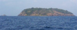
 Kerekund, a rocky islet 19m high, lies about 4 miles S of Murdeshvar and on the W edge of the coastal reef. A rock, 3m high, and a rock, 7m high, lie about 0.5 mile NNE and SE, respectively, of the islet.
Between Kerekund and Bhatkal Fort, about 4.5 miles SE, the low and sandy coast is fringed by foul ground extending up to 1.8 miles offshore.
Shirali (Hog Island), about 1 mile S of Kerekund, is a peaked island 109m high.
Two rocks, each drying 1.2m, lie close W and 0.2 mile SE, respectively, of the island.
When in the vicinity of this island do not enter into depths of less than 18m.
Ebook | Arabian Sea
|