Ujung Raja, S Samalanga village, a low promontory, may be recognized at some distant by a grove of high trees near its extremity. There is a fringing reef off Ujung Raja; it should not be approached in depths less than 15m.
Limitations.—Five berths in Kruenggeukueh Harbor handle bulk fertilizers and general cargo. These berths are described counter clockwise, beginning at the fertilizer plant situated on the W side of the harbor, as follows: 1. Berth A is 200m long, with a depth of 10m alongside. The ...
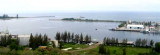
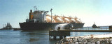
Arun Marine Terminal is situated at Blanglancang Harbor. In the approach to Blanglancang Terminal there are eight prominent storage tanks. About 0.8 mile to the SW of the terminal there are four conspicuous flares.The refinery is serviced by two offshore mooring areas, as well ...
Sigli is situated at the SE mouth of Krueng Baro, which flows into the sea about 9 miles SE of Ujung Pidie, and that is the principal river on this part of the coast. The port is used only by small craft.
Ug Hagu consist of a single quay with a length of 20m, a width of 5m, and a depth alongside of 7m. Vessels are restricted from berthing during night time at Lhokseumawe/Ug
Hago Wharf or Blanglancang SBM/MBM. Blanglancang Harbor is open for 24
hour service.
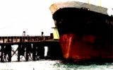
Old Lhokseumawe Harbor has a small pier 60m long, with a 2.4m depth alongside. Only barges and small vessels under 500 dwt can berth there. Old Lhokseumawe Harbor can be readily identified by a ridge of hills, 152m high, clear of trees and grass covered.Channel depth in LHOKSEUMAWE ...


 Ujung Raja, S Samalanga village, a low promontory, may be recognized at some distant by a grove of high trees near its extremity.