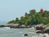
Cannanore Light is shown from a white, concrete column with red bands 1 mile WNW of Fort St. Angelo. A red conical buoy is moored about 0.5 mile SE of the fort from October to May and marks the approach to the inner anchorage for small craft. The coast between Cannanore and ...
Sacrifice Rock, 18m high and conspicuous, lies about 6.5 miles WNW of Kadalur Point. It consists of granite and, having a white appearance, can be seen 10 miles in clear weather. The passage between this rock and the coast is free of dangers, but vessels using it should keep near ...
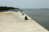
Azhikal, with a thriving timber trade, lies on the S bank of the river, about 1 mile within the entrance. Boundary pillars, NW and SE of the river entrance, define the limits of the port. Presently the port has only one wharf, 50m in length, that can accomodate one vessel up to ...
Kadalur Point, low but prominent, is covered with palm trees, over which will be seen a large round tree. Hills gradually rise NE of the point; the nearest summit is 78m high, about 1.3 miles NE of the point.The coastal reef extends about 1.5 miles W and 1.3 miles S from the point. ...
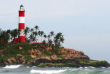
Kotte Kunnu, a bluff point 52m high, at the SW extremity of a headland, is joined to the more elevated land by a low neck; a fort lies on Kotte Kunnu. Mount Dill Light (Kotte Kunna Light) is shown from a white triangular stone tower with red bands on the bluff point.A stranded wreck ...
Elattur Cape, about 4 miles farther SSE, is low and rocky, with coconut palms close inland. The mouth of the Elattur River, a shallow and rocky river, lies about 1.3 miles N of the cape.


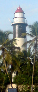
 An ancient fort stands on rising ground near the coast. Tellicherry Light is shown from the NW bastion of the fort.
")