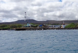

Puerto Seymour (Baltra Island)
48nm
304°
Easy entrance. The charts call it Caleta Aiolian, ...
18 Dec 15
Joëlle
| Latitude | Longitude | |
| DMS | --- | --- |
| DM | --- | --- |
| DD | --- | --- |


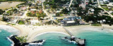
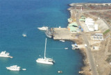
 Puerto Baquerizo Moreno is the capital of the province of Galapagos. It is the main port, located on the southwertern tip of San Cristobal island.
Entry Information: On approach, stay clear of the SE point. Come in midway between the North point of land, which has a lighthouse on it and the northernmost of 2 tall, white/yellow, lighted buoys, with a short red one in the middle. The red buoy marks a wreck or pinnacle and the waves break quite high near it, so be aware and stay clear. Also, don’t come too close to the lighthouse point, as there is a big surf break there and shallow water.
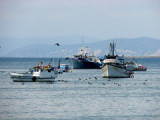
Anchorage: Good holding sand bottom but with big rocky patches which show up from the deck in 30’ clear water. On the Southern side, near the Navy buildings, it may be calmer and better protected from the S swell at some times of the year, but it is also MUCH more rocky. No stern anchor required. Water taxi service, there are only 2, call on channel 16. Port Captain is located to your right on the beach facing the anchorage. This is also a good beach to land a dinghy. HOWEVER, there are a lot of BIG sea lions around the anchorage and beach. They have no problem getting up on a swim step, or into a dinghy, so the water taxi may save you a messed up (or sunken) dink.
Groceries: Saturday morning at a public mercado (ask a local for directions) for the best veggies. Dos Hermanos on Quito is best tienda.
 (San Cristobal I)")