Nagwa Point is the S extremity of Diu Island, about 3.5 miles E of Diu Head. It is a dark bluff, with cliffs 9.1 to 12.2m high, rising to a 20m summit marked by a bush. Shoal water, over which the sea breaks occasionally, extends about 0.3 mile WSW from Nagwa Point.
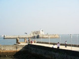
Diu Harbor, between the E end of Diu Island and the mainland N, is open E and somewhat encumbered by shoals. There are end number of forts and monuments in Diu. One of such fort and monument is Fortim-do-Mar in Diu. Located exactly at the opening of the creek, this opulent stone
structure ...
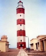
Diu Head, a rocky bluff about 30m high, can be identified by the lighthouse, two long buildings, and a small temple lying near its summit. From this summit the land slopes gradually E, terminating in a rocky point, on which there is a cairn, 8m high.
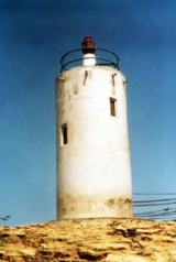
Nawabandar is a promontory situated 2 miles E of Diu Harbor; the intervening coast is high, with deep water close to it. A light is shown from a white circular building on the promontory. The town of Delvada, about 2.5 miles NW of Nawabandar, has a large conspicuous temple with twin ...


 Petit port protégé par une digue.
 Small port protected by a breakwater.