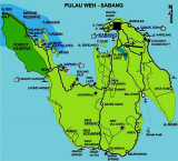
Pulau Breueh (Aceh - N Sumatra)
67nm
270°
It attains a height of 685m at Ceumo (Tjeumo), a summit in the middle of the island.
This is a rugged island, with several bays affording anchorage according ...
19 Jan 12
Jojo
| Latitude | Longitude | |
| DMS | --- | --- |
| DM | --- | --- |
| DD | --- | --- |

 North Sumatra stretches across the island between the Indian ocean and the Strait of Malacca.
It borders Aceh province on the northwest. The province contains a broad, low plain along the Strait of Malacca on which the provincial capital, Medan, is located. In the south and west, the land rises to the mountain range that runs the length of Sumatra; the mountains here are dominated by Lake Toba, formed from the caldera of an ancient volcano.
Several large islands in the Indian Ocean off the coast of Sumatra are part of North Sumatra, most notably Nias, and the Batu Islands.
North Sumatra has international seaport at Belawan, Medan and now to prepare a new seaport at Kuala Tanjung.
Winds—Weather.—At the N and NE portion of Sumatera, during the Northeast Monsoon, there is generally a swell on the coast, which gives rise to a considerable sea in the afternoon if accompanied by a stiff sea breeze. Both subside quickly, so that the water is generally smooth at night. At times the monsoon blows strongly for some days, at which times communication with the shore is impracticable.
December and January are considered to be the worst months. The Southwest Monsoon is the best for landing on this portion of Sumatera.
Rain occurs throughout the year in Sumatera. The period of the greater or less rainfall on the N half of the island does not correspond with the periods of the monsoons.
The greatest rainfall on the N coast of Ujung Masam Muka and the off-lying islands usually occurs in the months of October and November, the months preceding the change to the Northeast Monsoon. The least rainfall occurs in February and March, the months preceding the change to the Southwest Monsoon. The rainfall on the off-lying islands is about double that on the N coast.
The climate of the N coast of Sumatera (NW extremity) is damp. The temperature ranges from 25° to 35°C. It is subject to great and sudden changes, which may vary in different localities.
On the N and NW coast the months of March and April are hot.
Tides—Currents.—The flood sets E on the N coast of Sumatera and the ebb W, rarely exceeding 2 knots at springs.
At neaps, they are sometimes imperceptible, except at the points or over banks and narrow channels.
The currents are affected by the constant current out of the Strait of Malacca, which takes a W direction along the N coast through Sempitan Malaka (Malacca Passage). The currents pass through Selat Benggala (Bengal Passage); for the greater part of the year the ebb current is longer and stronger than the flood current.
Pilotage.—Pilotage is compulsory for all the ports of the Republic of Indonesia where pilots are available. Signals for a pilot are in accordance with the International Code of Signals.
Regulations.—An extensive prohibited area, in which fishing and other activities not associated with the innocent passage of foreign vessels are prohibited, has been established off the coastline of NW Sumatera and is bound by lines joining the following positions: a. 5°43.2'N, 94°46.5'E. b. 5°51.0'N, 94°46.7'E. c. 6°13.5'N, 94°59.5'E. d. 6°16.0'N, 95°10.1'E. e. 5°40.4'N, 96°00.5'E. f. 5°29.0'N, 96°49.4'E. g. 5°29.2'N, 97°33.5'E. h. 5°01.0'N, 98°03.4'E. i. 4°33.8'N, 98°25.9'E.
This prohibited area does not apply to foreign vessels supporting offshore terminals. Mariners should consult with local authorities for further information.
Caution.—Indonesia has implemented the IALA Maritime Buoyage System. In some areas, however, obsolete systems may still exist. As a result of cataclysmic damage created by a major tsunami in 2004, ports in this sector may be closed; depths, sea bed topography, and buoyage may not be as charted. Mariners are urged to contact local authorities for the latest information.
The coast between Ujung Masam Muka and Tanjung Jambuair is about 140 miles in length.
At various distances inland there are several mountain ranges.
Vessels can fix their positions by using these mountain peaks. Many of these peaks are within 12 miles of the coast.
Ebook | Andaman sea
|