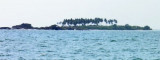
Saint Mary Isles (W India)
8.8nm
335°
12 Mar 12
Jojo
| Latitude | Longitude | |
| DMS | --- | --- |
| DM | --- | --- |
| DD | --- | --- |

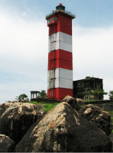
 Kap Light, about 8 miles SSE of Malpe, is shown from a white tall masonry tower with black bands standing on a rock near a battery in ruins.
Kap Rock, 13m high, is prominent about 1.5 miles NNW of the light. A rock, 1m high, with a drying rock close NE, lies about 1 mile SSW of Kap Rock.
Mulki Rocks, some of which are 13m high and of black basalt, lie about 4 miles WSW of Kap Light.
Caution.—Vessels in this vicinity at night should keep in depths of not less than 24m. A 4m depth lies about 3 miles SW of Kap Light. Kunjar Gudda, 105m high, is a prominent landmark about 4 miles NE of Kap Light.
Ebook | Arabian Sea
|