Great Nicobar island

Great Nicobar island

Para ubicar con precisión. Actualizar si es necesario.

Ubicación

Great Nicobar island
LatitudeLongitude
DMS------
DM------
DD------

Característica

Isla / Atoll

Descripción

Great Nicobar is the largest of the Nicobar Islands of India, it is also the southermost point of India.
The island covers 1045 km² but is sparsely inhabited.
The island was severely affected by the 2004 Indian Ocean earthquake tsunami with many deaths, and was cut off from all outside contact for more than a day.

The island has several rivers, including the Alexandra, Amrit Kaur, Dogmar and Galathea. Virtually all rivers flow in a southern or southwesterly direction, which is indicative of the general slope of the terrain across the island.
There are undulating hills throughout the island, with the main range running in a north-south orientation. Mount Thuillier, which is part of this range, has the highest elevation of any point in the Nicobars, at 642 m above sea level. Indira Point was submerged in the 2004 tsunami.

2011/11/30
Actualizar
Jojo
Great Nicobar island
2011-11-30
Actualizar
Jojo
Ebook

Andaman sea

  • 178 sites
  • 164 photos
  • publication date: 7 Jul 2023
  • .pdf file size: 54 Mb
Comparta sus comentarios o fotos en "Great Nicobar island"

Sitios alrededor de Great Nicobar island

Flying distances - Direct line

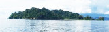
Kondul island Nicobar

14nm
339°
Kondul island, high and rocky on its N side, rises to a heigh of 92 m. The shape of this island looks elongated. Kondul was amongst those islands that were devastated by the tsunami of 2004. Population of Kondul Island according to 2001 census is 150. Before tsunami hit this island, ...
1 Dec 11
Jojo

Nancowry island (India)

60nm
345°
Nancowry Island lies close S of and overlaps the S end of Camorta Island. Nancowry Harbor, a secure landlocked inlet, lies between them. The E entrance of Nancowry Harbor lies between the SE end of Camorta Island and the NE end of Nancowry Island. The approach to this entrance leads ...
29 Nov 11
Jojo

Kabra islet (Nicobar)

18nm
11°
Kabra Island, 63m high, lies in St. Georges Channel almost 3 miles N of Murray Point, the N end of Great Nicobar Island.It is part of great Nicobar group of Islands. It has thick growth of commercial vegetation.
The inhabitants from nearby Kondul and Little Nicobar islands ...
1 Dec 11
Jojo

Trak and Treis islands Nicobar

30nm
342°
Trak Island lies 5 miles WNW of Sombrero Point; Treis Island lies 1 mile SE of Trak Island.
Both islands are small, reef-fringed, and surrounded by sunken rocks.
A rock, which has a depth of less than 1.8m, lies about midway between Treis Island and Sombrero Point.
30 Nov 11
Jojo

Meroe island Nicobar

33nm
332°
Miroe Island, low and small, lies 10.5 miles WNW of Sombrero Point, the N extremity of Little Nicobar Island.
Miroe Island has been reported to be a good radar target up to 19 miles.
30 Nov 11
Jojo

Trinkat island Nicobar (India)

66nm
348°
Trinkat Island, which lies between 1.5 and 2.5 miles E of the S part of Camorta Island, is separated from that island to the W and NW by False Bay and Beresford Channel.
Trinkat Island is low, level, and covered by coconut trees. An extensive reef surrounds the island. Morrel Point, ...
30 Nov 11
Jojo