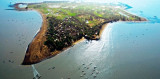

Magdalla port (W India)
44nm
352°
The actual port of Magdalla is located about 5 miles upstream on the S bank of the ...
1 Mar 12
Jojo
| Latitude | Longitude | |
| DMS | --- | --- |
| DM | --- | --- |
| DD | --- | --- |

 Between Suvali Point and Daman, is an alluvial belt through which the Tapti River forms a deep and fertile delta.
Daman (Damoa) lies on both sides of the Damanganga River; it can be identified by the forts on either side of the river entrance and by two square steeples and its white buildings. Other landmarks are a 109m hill, with an idgah, or Mohammedan place of prayer, on its summit, about 2.8 miles NE of the river entrance; Indragad Hill, 108m high, with a fort in ruins on its summit, about 3.3 miles SSE of the river entrance; and Jogmari Hill, 231m high, about 2 miles farther SSE.
Daman Light is shown from a white masonry tower on the bastion of the fort on the S side of the entrance.
The coast between Daman and Vadhavan Point, about 30 miles SSW, is bordered by extensive reefs and foul ground extending up to 4 miles offshore. Vessels should not approach this coast in depths of less than 18.3m when navigating in the vicinity.
")
Ebook | Arabian Sea
|