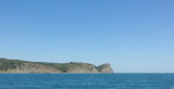
La mer Noire est située entre l'Europe et l'Anatolie. Large d'environ 1 150 km d'ouest en est et de 600 km du nord au sud, elle s'étend sur une superficie de 413 000 km². Elle communique au nord avec la mer d'Azov par le détroit de Kertch, et au sud-ouest avec la Méditerranée par le Bosphore, la mer de Marmara et le détroit des Dardanelles.
Sea of Azov The Sea of Azov ( Azovskoye - Azovs'ke - Azaq deñizi) is the world's shallowest sea, linked by the Strait of Kerch to the Black Sea to the south. It is bounded on the north by Ukraine, on the east by Russia and on the west by the Crimean peninsula.
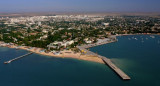
Formalities - Feodosia is a port of entry. Officials will come to the yacht. The crew should not attempt to leave the yacht until all formalities have been completed.. One days notice should be given prior to departure. Berths - Alongside the pier or where directed.
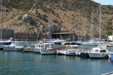
Formalities - Yalta is a port of entry. Officials will come to the boat. The crew should not attempt to leave the yacht until formalities have been completed. One days notice of departure is required.


 La mer Noire est située entre l'Europe et l'Anatolie. Large d'environ 1 150 km d'ouest en est et de 600 km du nord au sud, elle s'étend sur une superficie de 413 000 km².