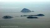

Ilhas Cagarras
12nm
195°
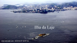
Sunken rocks extend 183m S of the E end of Ilha de Palmas. Ilha do Pai and Ilha da Mae lie on the NE side of the approach to Baia ...
16 Jan 16
Joëlle
| Latitude | Longitude | |
| DMS | --- | --- |
| DM | --- | --- |
| DD | --- | --- |

 Baia de Guanabara se trouve dans l'Etat de Rio de Janeiro. Elle entre d'environ 30 km à l'intérieur des terres et est large de presque autant. Elle est parsemée de nombreuses îles et îlots.
A l'W de la baie s’étendent les villes de Rio de Janeiro et Duque de Caxias, et à l'E se trouvent les villes de Niterôi et Sao Conçalo. Quatre autres municipalités entourent le rivage de la baie.
La profondeur est de 17 m à l'entrée de la baie et de 8 m à la verticale du pont Rio-Niterôi.
La baie est traversée par le pont de Rio-Nietrôi (13,29 km de long) avec une travée centrale de 72 mètres.
Dans la baie, les vents locaux soufflent avec une grande régularité. La régularité de la variation de ces vents ne cesse que dans le cas de mauvais temps (habituellement de juin à octobre) où les vents soufflent du SW ou S.
Pendant cette période, les vents de SE provoquent une mer confuse dans Enseada de Botafogo et dans Enseada de Flamenco. De forts orages se forment à l'intérieur de la baie, par temps très chauds de Janvier à Mars, et généralement quand la mer brise soit avec un décalage ou pas. Ils sont accompagnés par des vents de courte durée, mais violents, et de fortes pluies.
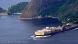
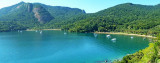
Les îles, à l'entrée de la baie, sont accores et peuvent être approchées en toute sécurité. Le passage entre Ilha Rasa et Ilha do Pai est le plus large, c'est généralement celui qui est utilisé par les navigateurs qui approchent de la baie par l'E.
")
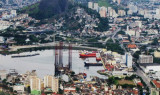
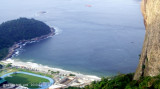
 Baia da Guanabara is located in the state of Rio de Janeiro. It is 31 km long and 28 km wide at its maximum. It contains many islands and islets.
On its western shore lies the city of Rio de Janeiro and Duque de Caxias, and on its eastern shore the city of Niterôi and Sao Conçalo. Four other municipalities surround the bay's shores.
The depth is 17 m at the enter of the bay and 8 m vertically to the Rio-Niterôi bridge.
The bay is crossed by the Rio-Nietrôi bridge (13,29 km long) with a central span 72 metres.
In Baia de Guanabara, local winds blow with great regularity. The regularity of the variation of these winds ceases only in the event of bad weather. In this event, usually from June to October, the winds blow from the SW or S.
During this period, SE winds cause a confused breaking sea in Enseada de Botafogo and Enseada de Flamengo. Strong thunderstorms form in the interior of the bay on very hot days from January to March, and generally when the sea breeze either lags or does not blow. They are accompanied by short, but violent, winds and heavy rains.
The islands in the approach to Baia de Guanabara are steep-to, and may be approached safely. The passage between Ilha Rasa and Ilha do Pai is the widest, and is the one generally used by vessels approaching from the E.
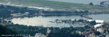
All clearance formalities must be undertaken in the commercial harbour of Rio de Janeiro, which is not recommended to be entered by yacht, as it is much more convenient to stay in one of the marinas and go to the necessary offices by public transport. Marina da Gloria is the most conveniently located for a visiting yacht and the office will help with instructions as the various offices are best visited by taxi.
If moving across the harbour to Niteroi, be sure to clear out of Rio first.
There are several anchorages and marinas in Rio de Janeiro, one of the most conveniently situated being Marina da Gloria close to Rio's smaller airport. The marina is very crowded with local boats, but space is usually found for visitors, although facilities are limited.
Another option is to anchor off the Royal or "Botafogo" YC. They make a charge for use of their moorings and facilities.
Alternativly, mooring at Niteroi on the eastern side of this large harbour is possibly a cheaper and safer option.
Ebook | SE Brazil
|
Ebook | SW Atlantic Ocean
|