
Khawr al Qulayah Bahrain
13nm
58°
A channel, with a least depth of 9.5m, leads through Khawr al Qulayah to a basin, with the same depth, off Mina Salman, although caution is necessary, ...
17 Oct 11
Joëlle
| Latitude | Longitude | |
| DMS | --- | --- |
| DM | --- | --- |
| DD | --- | --- |


 Bahrain, officially the Kingdom of Bahrain, is a small island state near the western shores of the Persian Gulf.
Bahrain is an archipelago of 33 islands, the largest being Bahrain Island, at 55 km (34 mi) long by 18 km (11 mi) wide. Saudi Arabia lies to the west and is connected to Bahrain by the King Fahd Causeway. Qatar is to the southeast across the Gulf of Bahrain. The planned Qatar Bahrain Causeway will link Bahrain and Qatar and become the world's longest marine causeway.
In Arabic, bahrayn is the dual form of bahr ("sea"), so al-Bahrayn means "the Two Seas".
Bahrain is a generally flat and arid archipelago in the Persian Gulf, east of Saudi Arabia. It consists of a low desert plain rising gently to a low central escarpment with the highest point the 134 m Mountain of Smoke (Jabal ad Dukhan). Bahrain has a total area of 665 km2, which is slightly larger than the Isle of Man, though it is smaller than the nearby King Fahd International Airport near Dammam, Saudi Arabia (780 km2).
Al Bahrayn is the principal island in an archipelago of islands, including Al Muharraq and Sitrah, which together form the independent Sovereign Arab State of Bahrain. Al Bahrayn, about 35 miles W of Ras Rakan, has low coasts and is uncultivated except for a belt of fertile land that is along the N end.
From a position about 4 miles S of the N coast, a rocky tableland extends S for several miles and stretches across the island from side to side in a series of small cliffs. Al Bahrayn is reported to give good radar returns up to 25 miles distant.
Jabal ad Dukhan is a small compact group of dark hills rising midway between the E and W coasts.
The hills are usually the first objects seen when approaching the island. Oil tanks and water tanks on the hills and at Al Awali, 3 miles N, are prominent.
Winds—Weather.—The shamal reaches gale force at intervals but raises little or no ground swell at most of the moorings in Al Bahrayn; however, a short choppy sea makes up and is bothersome for small vessels.
Tides—Currents.—From Ras Rakan, the tidal currents set S along the coast. The currents are felt everywhere on Great Pearl Bank, especially near the reefs and islands.
The edge of the bank extends WNW from a position about 35 miles NE of Ras Rakan. There are overfalls in places on the bank.
Off Al Bahrayn, and among the off-lying reefs, the tidal currents are very irregular and are much affected by the wind, but usually follow the trend of the reefs. At springs, the currents attain a velocity of 1 to 3 knots.
Jazirat al Muharraq, low and sandy, has conspicuous groves of date palms and several villages along its coasts. Reefs, extending up to 3.5 miles offshore in places, fringe the island on all sides.
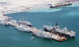
The reef extending S from the island terminates in Qassar Diwan, a rock about 0.3m high. There is a ship repair yard (Arab Shipbuilding and Repair Yard) and drydock on the S end of the reef, NE of Qassar Diwan.
A causeway extends about 4 miles SSE of Jazirat al Muharraq. It is fronted by a coastal bank with depths of less than 5m.
A lighted buoy, with a racon, marks the limit of the shoal area extending SSE of Jazirat al Muharraq.
Qassar Khusayfah is a low islet lying on the reef N of Jazirat al Muharraq.
Qalali, a village on the NE extremity of Jazirat al Muharraq, has several prominent towers associated with the airport SW of the village. Samahij, Al Dayr and Rayya are three villages on the N coast of the island.
Al Muharraq, a large town at the SW end of Jazirat al Muharraq, is connected to Al Manamah, on Al Bahrayn, by a stone causeway and a fixed bridge carrying a road. The bridge, with a vertical clearance of 4.6m, spans the deepest part of a boat channel.
The ruins of Abu Mahir, a fort with one large and three small towers, stands on a low spit at the S end of town.
The Quarantine Station and a minaret stand close N of the fort.
Al Hadd, a town located at the SE extremity of the island, is prominent when approaching from the E. A water tower in the town is conspicuous.
Sitrah, an island, lies close off the NE coast of Al Bahrayn. There are a few settlements among the date palms on the N side of the island. Two piers, one a T-head pier with a depth of 12m alongside, extend from the causeway which originates off the SE side of Sitrah.
About 0.5 mile SW of the S extremity of Sitrah, and on the E side of Al Bahrayn, is a concrete pier extending 0.4 mile SE, in a depth of 3.7m.
An oil refinery, oil tanks, and a high chimney are conspicuous about 1 mile inland from the root of the pier.
Sitrah Causeway, extending about 3 miles ENE from the E side of Sitrah, terminates at Sitrah No. 2 Oil Loading Wharf. The causeway carries a road and oil pipelines. A conspicuous water tower, marked by red lights, stands l.5 miles NW of the root of the causeway. South of the oil tank farm there are a few scattered villages, but mostly the coast is barren and uninhabited.
The channel separating Sitrah from Al Bahrayn is very shallow and is spanned by a road bridge, which also carries oil pipelines from the Al Bahrayn refinery to the oil-loading piers.
Ebook | Persian Gulf - Arabian Gulf
|